
The Lake Frank Trail is an important planned trail that will connect the Rock Creek Trail to Lake Frank, but it is in jeopardy due to nearby homeowner opposition. The paved 10 foot-wide trail will be a superb amenity that will greatly improve access to the lake, provide for recreation and exercise and serve as a high quality bikeway. It will also be an important piece of the future North Olney Trail (see map below) that will link the Rock Creek Trail to Olney five miles away, helping the environment by supporting bike transportation instead of driving. Continue reading here.
Alert: Please testify or attend the June 10th Planning Board hearing. The hearing will start at 7:30 pm and is located at 8787 Georgia Avenue in Silver Spring. Sign up to speak by calling 301-495-4605 or using the Board's sign up page. If you can't testify, please send comments in writing to the following:
See the staff memo prepared for the hearing by the Parks Department for lots of information. The Planning Board hearing agenda and contact information is located at http://www.montgomeryplanningboard.org/agenda/2010/agenda20100610e.html (see agenda item 13 at the bottom).
Please tell county and state officials that you support the trail by sending emails to these parties:
(It's helpful to add your own comments and personal perspective, such as why you use trails…)
To Mr. Neil Pedersen [or other recipient]:
I strongly support construction of the hard-surface Lake Frank Trail connecting the Rock Creek Trail to Lake Frank. I ask that it be built as soon as possible, and that it use state ICC stewardship funds as currently planned. I am a park user and will certainly benefit from this trail. The trail will be an important part of the countywide bikeway network and will support more trips by bike instead of by car. Please move the project forward. Thank you.
[signed, your name and city/community]
The Lake Frank Trail is a planned paved hiker-biker trail that will connect the Rock Creek Trail to Lake Frank. The trail will provide much better access to the lake, provide for recreation and exercise, and serve as a high quality bikeway. It will also be an important piece of the future North Olney Trail (see map below) that will link the Rock Creek Trail to Olney five miles away. That will make it an essential link in the bike transportation network. The North Olney Trail and Lake Frank segment of that trail have been in county plans for several years.
Unfortunately a group of neighbors who live adjacent to Lake Frank is stridently opposing the trail based on its proximity to their homes, a problem we face all too often when new trails are built. To stop the trail they are attempting to take away its state funding. First they tried to reroute the trail to a much inferior location that would be farther from their homes. Having failed at that, they are now seeking to take away state funding already allocated for the trail. The state funds are provided by the ICC environmental stewardship program that's paying for many projects including trails. Opponents are pushing to implement a parking lot removal project with the same funds so that no funds will be left for the trail. The parking lot project is worthwhile but is already slated to be done later and is not at risk. The trail is very much at risk due to neighborhood opposition.
Neighbors are saying they were not directly notified of the county's intention to build the trail using ICC funds. But there were numerous Gazette articles talking about the Upper Rock Creek Trail Corridor Plan as it was being developed, and that plan clearly states the county's intention to use ICC funds and consider a new alignment.
We all respect the beauty of the lake. It is a more natural and uncrowded setting than Lake Needwood. A single paved path passing through the lake area is certainly consistent with that and will improve access. We also support construction of a continuous natural surface trail around the entire lake to ensure a hiking experience that for the most part stays away from any asphalt.
Neighbors opposing the trail are using the slogan "Take Back Our Lake". But we believe county parks belong to everyone and not just one community.
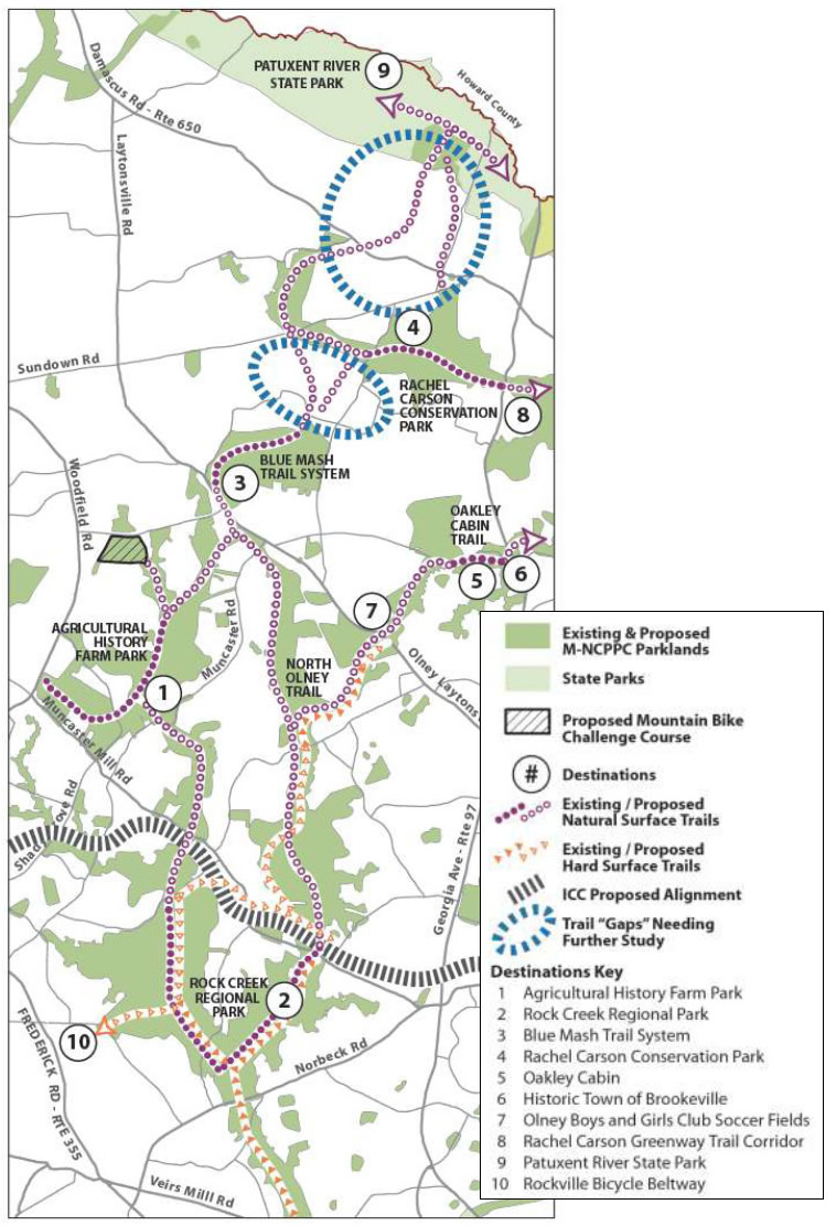
The above map shows the full North Olney Trail. It is the orange dotted line starting roughly at the fork with the Rock Creek Trail (just south number "2") and ending at the number "7".
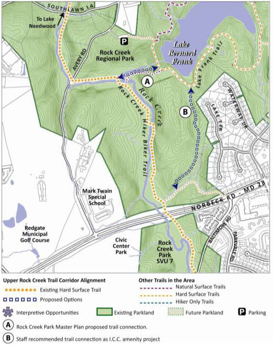
The above map shows the feasible route "B" embraced by FHWA, the state and the county Parks Department. It also shows the non-feasable route "A" requested by neighbors living on the streets shown. There is also an alternative "N" (not shown) that the neighbors have been supporting lately, but it is probably not a workable route due to length and tree cutting. Route "A" is not feasable because of considerably higher cost, rock cutting and greater environmental impact (clearing, switchbacks).
Opponents say they were not duly informed of the county's plans to use ICC money to switch trail alignments. But several Gazette articles focused on the Upper Rock Creek Trail Corridor Plan as it was being developed, on opportunities for public input, and on the trail alignment switch. The corridor plan clearly states the county's intention to use ICC funds to build the trail. Question: How could community associations that back up to Rock Creek Park be so inattentive that they were unaware of the development of the corridor plan despite all these articles in the county's newspaper? The VP of the umbrella Montgomery County Civic Federation even attended one of the public meetings. In most counties, a Parks Department that publicizes a plan through press releases and sees its verbiage quoted verbatim in several newspaper articles would consider its public notification responsibilites to have been fulfilled.
We support the WABA (Washington Area Bicyclist Association)
This page sponsored by MoBike (Montgomery Bicycle Advocates) at www.mobike.org
Send us an email at...